For brain-melting images of earth as it is seen from space, NASA’s Earth Observatory is the spot. The Earth Observatory’s Image of the Day is a vital part of any earth enthusiast’s daily web feed. As we close in on the end of the year, it’s a good time to take a look back at some of NASA’s greatest image hits over the year. Here is a handful of stellar shots, courtesy of The New Yorker.
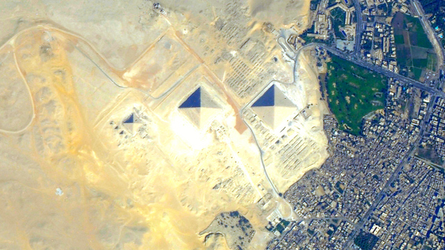
1. The pyramids of Giza, Egypt, as seen from the International Space Station on July 25, 2012. (Astronaut photograph by the Expedition 32 crew)
2. On March 15, 2012, a steam plume blows south from the peak of the northernmost volcano on Pagan Island, in the Northern Marianas. (Astronaut photograph by the Expedition 30 crew)
3. In February, NASA’s Terra satellite flew over Antarctica’s Princess Astrid Coast and detected swirls of green amid the ice. (NASA Image courtesy Jeff Schmaltz, LANCE/EOSDIS MODIS Rapid Response Team at NASA GSFC)
4. On September 18, 2012, the Advanced Land Imager on NASA’s Earth Observing 1 satellite made this image of wildfires in Idaho using visible, near-infrared, and shortwave-infrared light. (NASA Earth Observatory image by Jesse Allen and Robert Simmon)
5. On November 12, 2012, NASA’s Aqua satellite captured this image of the Guadalquivir River emptying a heavy load of sediment into the Gulf of Cÿdiz, along Spain’s southwestern coast. (NASA Image courtesy Jeff Schmaltz, LANCE MODIS Rapid Response Team at NASA GSFC)
6. Rising three thousand metres from the floor of the Sea of Okhotsk, between Japan and the Kamchatka Peninsula, the Alaid Volcano is one of many active volcanos along the Kuril chain. May 18, 2012. (Astronaut photograph by the Expedition 31 crew)
7. Lake Powell, which extends across southeastern Utah and northeastern Arizona, started filling in 1963, when the Glen Canyon Dam was completed along the Colorado River. (Astronaut photograph by the Expedition 31 crew)
Hit up The New Yorker for more images in juicy high-res.